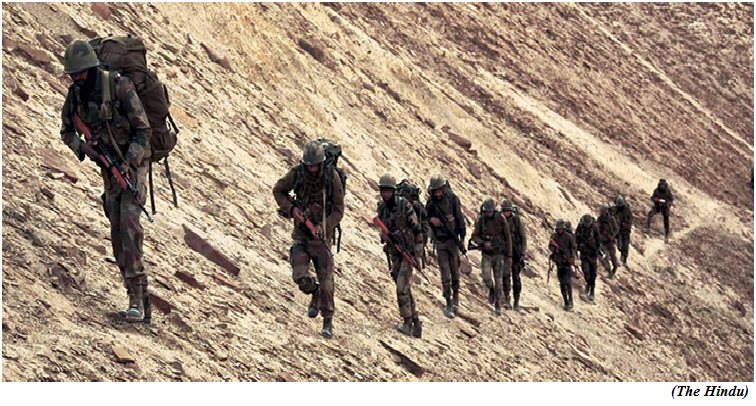
India has lost access to 26 out of 65 Patrolling Points in eastern Ladakh says research paper (GS Paper 3, Defence)
Why in news?
- India has lost access to 26 out of 65 Patrolling Points (PP) in eastern Ladakh, according to one of the research papers.
Details:
- The “play safe” approach of the Indian Army that restricts the movement of the district administration and locals in forward areas has turned areas that were once accessible into informal “buffer” zones.
- To avoid consternation with the Chinese People’s Liberation Army (PLA) that has placed high-resolution cameras at vantage points, the Army restricts the movement of graziers by installing check-posts and deploying personnel in disguise.
- The recent disengagement agreements at PP 15 and 16 resulted in the loss of pasture lands at Gogra hills, North Bank of Pangong Tso, and Kakjung areas.
Background:
- There are at least 30 PPs in eastern Ladakh along Line of Actual Control (LAC) are not being patrolled any more by Indian troops.
- These points were regularly patrolled before April-May 2020, when China started amassing troops close to the LAC in eastern Ladakh.
- Twenty Indian soldiers were killed in violent clashes with the PLA on June 15, 2020; at least four Chinese soldiers were also killed.
Salami Slicing:
- Presently, there are 65 PPs starting from Karakoram pass to Chumur which are to be patrolled regularly by the ISFs (Indian Security Forces). Out of 65 PPs, our presence is lost in 26 PPs (i.e. PP no. 5-17, 24-32, 37, 51,52,62) due to restrictive or no patrolling by the ISFs.
- Later on, China, forces India to accept the fact that, as, such areas have not seen the presence of ISFs or civilians since long, the Chinese were present in these areas.
- This leads to a shift in the border under control of ISFs towards Indian side and a buffer zone is created in all such pockets which ultimately leads to loss of control over these areas by India. This tactic of PLA to grab land inch-by-inch is known as Salami Slicing.
Play safe strategy:
- LAC in eastern Ladakh is dominated by physical patrolling or technical means and “there is no loss of territory due to disengagement in friction areas”.
- The graziers are encouraged and all facilities are being provided in conjunction with the civil administration.
- The Army has placed significant restrictions on the movement of civilians and graziers near the forward areas on the Indian side, indicating with their play safe strategy that they do not want to annoy the PLA by giving them the chance to raise objections on the areas being claimed as disputed.
Reason for migration:
- The unfenced borders have been serving as pastures for the nomadic community of Changthang region (Rebos) and given the scarcity of the rich pastures, they would traditionally venture into the areas close to the PPs.
- Since 2014, enhanced restrictions on the grazing movement and areas have been imposed on the Rebos by ISFs and this has caused some resentment against them.
- The soldiers are especially deployed in disguise to stop the movement of Rebos to the higher reaches that could be objected by the PLA and similarly the development works in the border villages like Demchok, Koyul which are under direct electronic surveillance of the PLA suffers, as they raise objections promptly.
- Over the years, this has resulted in the loss of livelihood and change in lifestyle patterns of border villages, which has led to migration.
SC panel questions need to revive oil palm plantations in Andamans
(GS Paper 3, Economy)
Why in news?
- Oil palm plantations raised in the Andaman and Nicobar Islands in the past have proven to be a total commercial failure, the Supreme Court-constituted Central Empowered Committee (CEC) has said, questioning the need to revive the commercial crop in the archipelago.

What was the issue before SC?
- The Union Territory administration, in January 2019, moved the Supreme Court seeking revocation of its 2002 ban on commercial and monoculture plantations on forest land in the Andaman and Nicobar Islands.
- The proposal is part of the government's efforts to meet the vegetable oil shortage in the country and reduce its import burden.
- The SC had asked the CEC to provide inputs on the Union Territory administration's proposal to lift the ban and divert 16,000 hectares of forest land for red oil palm plantations.
Key Highlights:
- The committee said any permission for diversion of forest land for red oil palm plantation in the archipelago in violation of the Forest Conservation Act, 1980, "is bound to open flood gates in all the states for similar agricultural purposes on forest lands".
- The CEC also said oil palm plantation might lead to encroachment of forest lands in the islands group and asked why the production of palm oil could not be taken up on the mainland.
- Since the focus of the proposal is on meeting the shortage of vegetable oil in the country, why cannot the production of palm oil be taken up on the mainland, where the oil palm plantations have been successfully raised.
- The application merely states that grasslands will be utilised for this purpose "without any specific reference to the existence of grasslands in Andaman and Nicobar Islands and location of such grasslands".
Illegal migration:
- The 16,000 hectares of forest land where the palm oil plantations are proposed to be raised has not been identified and demarcated.
- The committee also said the raising and maintenance of 16,000 hectares of commercial plantations will require engagement of 32,000 plantation labourers on a continuous basis at a very conservative estimate.
- It said the availability of such a large labour force in the islands is doubtful and the possibility of illegal migrants entering from neighbouring countries cannot be ruled out.
National Mission on Edible Oils-Oil Palm (NMEO-OP):
- In 2021, the Centre launched the Rs 11,040-crore National Mission on Edible Oils-Oil Palm (NMEO-OP) with focus on oil palm plantations in the northeast and the Andaman and Nicobar Islands due to their favourable climate for the purpose.
- India depends on imports to meet its requirements for edible oil and is its largest importer in the world.
- During 2020-21, India imported around 133.52 lakh tonnes of edible oils, costing around Rs 80,000 crore, the Centre said in its operational guidelines, prepared last year, for NMEO-OP.
- Of all the imported edible oils, the share of palm oil is about 56 per cent, followed by soybean oil (27 per cent) and sunflower oil (16 per cent).
- Domestic edible oil production has not been able to keep pace with the growth in consumption, which is above 250 lakh tonnes.
Way Forward:
- Citing damage done to rainforests and biodiversity by oil palm plantations in Southeast Asia, environmental experts have warned that their cultivation in the Andaman and Nicobar Islands could be disastrous.
Earth's core has stopped spinning and may be changing direction. What happens now?
(GS Paper 3, Science and Tech)
Why in news?
- A new study has now revealed that the Earth's inner core recently stopped spinning and then changed its spin orientation in the opposite direction.
- The study states that the globally consistent pattern suggests that inner-core rotation has recently paused.
- The rotation came to a grinding halt in 2009 and then it surprisingly turned in an opposite direction.

Cycle of Swing:
- Researchers have long believed that the inner core rotates, relative to the Earth's surface, back and forth, like a swing.
- One cycle of the swing is about seven decades, meaning it changes direction roughly every 35 years. It previously changed direction in the early 1970s, and predicted the next about-face would be in the mid-2040s.
What is Earth's Inner Core?
- Earth's layers are divided into three parts: the crust, mantle, and core.
- Earth's inner core was first discovered in 1936 as researchers were studying seismic waves from earthquakes that travel throughout the planet.
- It was the change in the waves that revealed Earth's core, which is around 7000 kilometers wide and made up of a solid center of iron wrapped inside the shell of liquid iron.
Variation:
- A 1996 study revealed that the travel times of seismic waves that traverse the Earth's inner core show a small but systematic variation over the past three decades.
- This variation is best explained by a rotation of the inner core and the rotation rate is on the order of 1° per year faster than the daily rotation of the mantle and crust.
- The team analysed earthquakes mostly from between 1995 and 2021 and the analysis revealed that sometime around 2009 the core stopped spinning and might be in the process of changing the spinning direction.
What happens now?
- Researchers have said that the rotation of the core is related to the changes in the length of the day and it could lead to small variations in the exact time it takes for Earth to rotate on its axis and that there are links between the different layers of the planet -crust, mantle, and core.
- The observations provide evidence for dynamic interactions between the Earth’s layers, from the deepest interior to the surface, potentially due to gravitational coupling and the exchange of angular momentum from the core and mantle to the surface.
Way Forward:
- So far there is no evidence to suggest that the change in the spinning could affect people living on the surface of the planet.
- The study can motivate some researchers to build and test models which treat the whole Earth as an integrated dynamic system.