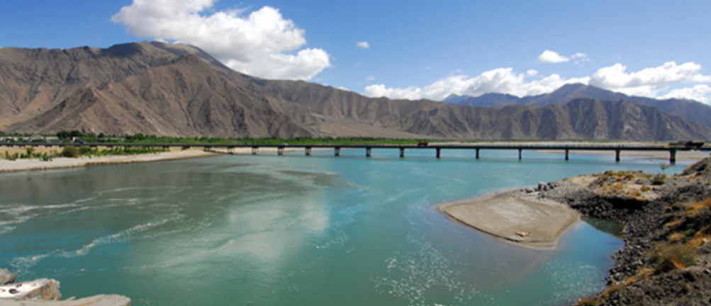
Chinese Bridge on Pangong Lake (GS Paper 1, Geography)

Why in News?
- The recent completion of a bridge by China across Pangong Tso Lake in Eastern Ladakh has introduced a significant shift in the strategic landscape of the India-China border region.
- This development not only enhances China's military capabilities but also raises several concerns for India.
- This article provides an in-depth analysis of the bridge's implications, the broader context of the India-China border dispute, and the strategic responses by India.
Introduction
- The operationalization of the bridge on Pangong Tso Lake by China marks a pivotal moment in the ongoing border tensions between India and China.
- The bridge connects the north and south banks of the lake, significantly improving the mobility of Chinese troops and military assets.
Overview of Pangong Tso Lake
Geographical and Historical Context
- Pangong Tso is a remarkable endorheic lake situated at an elevation of over 14,000 feet in the trans-Himalayan region of Ladakh.
- The lake stretches approximately 135 kilometers, with approximately one-third of its length in Indian territory and the remaining two-thirds under Chinese control.
- The eastern end of the lake lies in Tibet.
- Formed through tectonic activity when the Indian plate collided with the Asian plate, Pangong Tso is a vital geographical feature in the region.
- The lake's unique position and altitude contribute to its strategic importance, particularly in the context of the ongoing border dispute.
Disputed “Fingers” Area
The northern bank of Pangong Tso is characterized by spurs known as "fingers," which are crucial to the border dispute:
- Finger 8: India claims that the LAC runs through Finger 8, but its control extends up to Finger 4.
- Finger 2: China asserts that the LAC is at Finger 2, and recent tensions have seen Chinese forces blocking Indian movements beyond this point.
This disputed area has been a flashpoint in recent border skirmishes, with both sides reinforcing their positions and asserting control over strategic locations.
Strategic Significance of the Bridge
Military Implications
The completion of the bridge across Pangong Tso has several significant military implications for the region:
- Enhanced Mobility: The bridge provides the People's Liberation Army (PLA) with faster and more efficient access between the north and south banks of the lake. This reduced travel time is crucial for rapid troop deployment and logistical support.
- Strategic Access: By facilitating quicker movement to areas like Rezang La, where Indian forces outmaneuvered Chinese troops in 2020, the bridge strengthens China's strategic position.
- Reinforcement Capability: The bridge enables the PLA to reinforce its Moldo Garrison on the southern bank of the lake more rapidly. This garrison is critical for controlling the southern approaches to Pangong Tso.
Response to Indian Developments
- The construction of the bridge can be seen as a response to India's strategic actions, particularly the capture of key heights on the southern bank of Pangong Tso during the 2020 border clashes.
- The bridge's strategic placement suggests a deliberate effort by China to counterbalance India's military gains and assert control over the disputed region.
Broader India-China Border Dispute
Historical Context and Border Demarcation
The 3,488-kilometer India-China border is marked by several contentious areas where the Line of Actual Control (LAC) is not clearly defined. The LAC was established after the 1962 Sino-Indian War and is divided into three sectors:
- Western Sector: Ladakh
- Middle Sector: Himachal Pradesh and Uttarakhand
- Eastern Sector: Arunachal Pradesh and Sikkim
The primary disputes involve:
- Aksai Chin: Administered by China as part of Xinjiang but claimed by India as part of Ladakh.
- Arunachal Pradesh: Claimed by China as "South Tibet," while India considers it an integral part of its territory.
These disputes have led to sporadic clashes and ongoing tensions between the two nations.
Chinese Military Infrastructure Along the LAC
China has significantly enhanced its military infrastructure along the LAC:
- Connectivity Projects: Construction of roads such as the one from Samzungling to Galwan Valley to improve logistical support.
- Underground Bunkers: Development of new bunkers, camps, shelters, and radar sites to bolster military capabilities.
- Air Combat Enhancements: Deployment of additional aircraft and drones to address high-altitude combat challenges.
- Border Villages: Construction of dual-use border villages that serve both civilian and military purposes.
- Rear Area Infrastructure: Strengthening military and transport infrastructure on both banks of Pangong Tso to support rapid deployment and logistical operations.
India’s Response to Chinese Developments
Infrastructure Enhancements
In response to China's infrastructure developments, India has undertaken several strategic initiatives:
- Road Construction: India has constructed nearly 6,000 km of roads in border areas over the past five years, including 2,100 km along northern borders. Notable projects include the Darbuk-Shyok-Daulat Beg Oldie (DSDBO) road.
- Tunnel Projects: Ongoing all-weather connectivity projects such as the Zojila and Z-Morh tunnels in Ladakh, and the Sela tunnel and Nechiphu bridge in Arunachal Pradesh, aim to improve mobility and logistics.
- Troop Habitat: Investment of Rs 1,300 crore in infrastructure and habitat development in Ladakh, including eco-friendly solutions like Sheela shelters.
- Air Power Infrastructure: Enhancement of air power capabilities with heavy lift helicopters like the C17 Globemaster and C-130J Super Hercules for efficient resupply and troop movements.
Conclusion
- The construction of the bridge across Pangong Tso Lake by China represents a strategic shift in the ongoing India-China border dynamics.
- The bridge enhances China's military capabilities and reflects a broader trend of increased infrastructure and military readiness by both nations.
- In response, India is bolstering its own infrastructure and military assets to address the evolving strategic challenges.
- The situation underscores the need for continued vigilance and strategic planning in managing the complex and often volatile India-China border relations.


