Why have Bikaner and Barmer in Rajasthan reported land sinking in the last month? (GS Paper 3, Environment)
Context
- In the last month, two incidents of land subsidence took place in Rajasthan, alarming both geologists and the general public.
- Both incidents took place in desert districts, raising suspicions of a possible connection between them.
Occurred Incidents
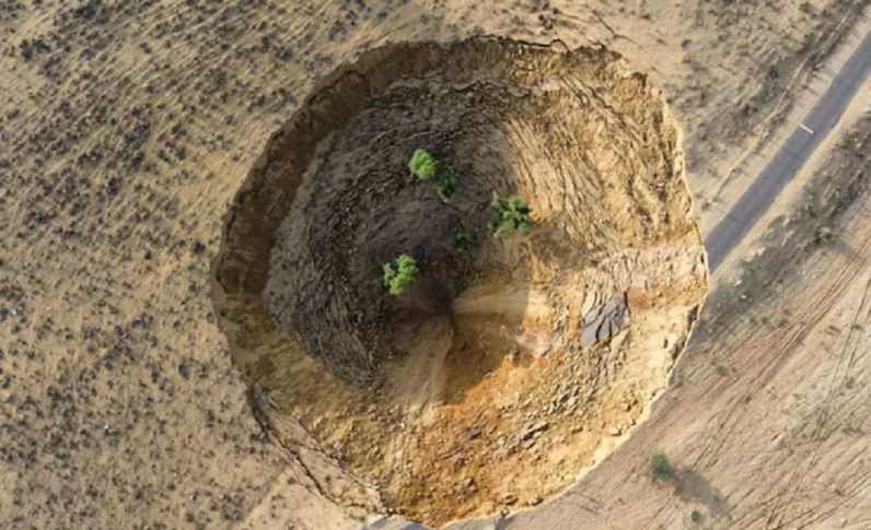
- On April 16, 2024, one and a half bigha of land collapsed around 3:30 am in Sahajrasar village of Lunkaransar tehsil of Bikaner district.
- At the time, a train full of passengers was passing by, narrowly escaping the sinking ground with the assistance of a tractor.
- The subsidence formed a pit about 70 feet deep, which, according to villagers, has since expanded to about 80-90 feet.
- The second incident occurred on May 6, 2024, in Nagana village of Barmer district, where two parallel cracks appeared in the ground over an area of about one and a half kilometres.
- A geological team has submitted its preliminary report to the administration on these incidents occurring in the two districts of the Thar Desert.
Responsible Factors
- The preliminary reports suggest that water is a common factor in both districts.
- GSI attributed excessive groundwater exploitation and reduced rainfall as the primary reasons for the pit in Sahajrasar. GSI officials visited Bikaner and prepared the report, but they declined to comment officially, stating the preliminary report had been submitted to the administration.
- A detailed report is forthcoming, based on satellite imagery, water data, and other technical information.
Analysis of Different Aspects
- Analysis of groundwater, rainfall and other relevant data along with geological field observations showed that the area is experiencing a high degree of groundwater depletion over the years.
- It may lead to drying up the water bearing aquifer rocks / sediments at the contact zone of the sub-surface hard rocks and aeolian deposits which may induce compaction of dried up pore spaces / voids, consequently reduction of volume of sub-surface strata and resultant loose sand bearing land subsidence.
- According to a groundwater status report by Bikaner district, the area primarily consists of light-textured, weakly structured sand and sandy loam soil.
- The preliminary GSI report also mentions reduced rainfall in the region.
- However, data from the state government’s water resources department’s annual monsoon report suggests an increase in average rainfall over the past 30 years.
- Despite the increase in average rainfall, there is a water shortage in the area, indicating that rainwater is not penetrating the ground effectively.
Water as the main cause
- The area’s only permanent pond remains due to historical deepening during famine relief efforts, indicating water recharge into the ground.
- The sinking land in Sahajrasar has historical precedence, with elders recounting a crater formed by a lightning strike many years ago.
- Over time, the pit filled, leaving a void that impacts the road’s construction and maintenance.
- According to a Barmer’s GSI officer, preliminary investigations suggest water as the cause.
- He explained that abundant multani mitti (Fuller’s earth) in the soil dissolved floodwater in 2005, creating a cave-like space underground.
- Subsequent water shifts created a vacuum, resulting in the emergence of cracks as the soil burst due to decreasing groundwater levels.
- GSI is monitoring the situation, with plans for geophysical surveys if cracks escalate.
Conclusion
- Local residents alleges groundwater overexploitation by Mangla, the crude oil company.
- While not highlighted in the preliminary report, investigations will consider this aspect if cracks worsen.