The case for open verifiable forest cover data (GS Paper 3, Environment)
Why in news?
- India is one of the few countries to have a scientific system of periodic forest cover assessment that provides “valuable inputs for planning, policy formulation and evidence-based decision-making”.
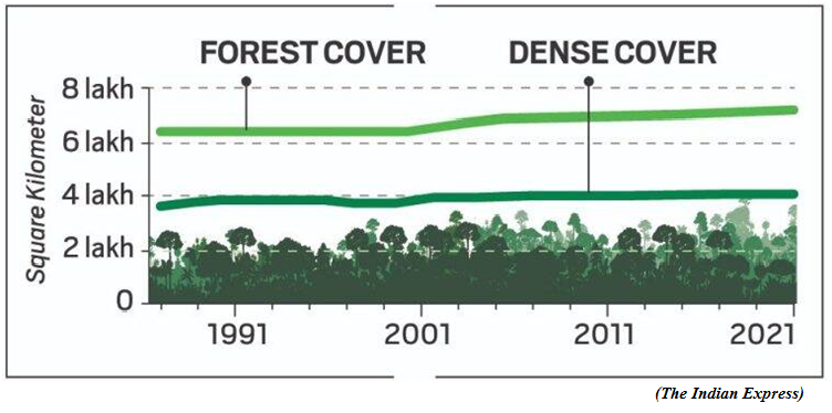
- Since 19.53% in the early 1980s, India’s forest cover has increased to 21.71% in 2021. Adding to this a notional 2.91% tree cover estimated in 2021, the country’s total green cover now stands at 24.62%.
Forest and tree cover:
- While the Forest Survey of India (FSI) started publishing its biennial State of Forest reports in 1987, it has been mapping India’s forest cover since the early 1980s.
- India counts all plots of 1 hectare or above, with at least 10% tree canopy density, irrespective of land use or ownership, within forest cover. This disregards the United Nation’s benchmark that does not include areas predominantly under agricultural and urban land use in forests.
- All land areas with tree canopy density of 40% and above are considered dense forests and those between 10-40% are open forests.Since 2003, a new category; very dense forest was assigned to land with 70% or more canopy density.
- Since 2001, isolated or small patches of trees, less than 1 hectare and not counted as forest are assessed for determining a notional area under tree cover by putting together the crowns of individual patches and trees.
NRSA versus FSI:
- The National Remote Sensing Agency (NRSA) under the Department of Space estimated India’s forest cover using satellite imagery for periods 1971-1975 and 1980-1982 to report a loss of 2.79% from 16.89% to 14.10% in just seven years.
- While reliable data on encroachment is unavailable, government records show that 42,380 sq km, nearly the size of Haryana of forest land was diverted for non-forest use between 1951 and 1980.
- However, the government was reluctant to accept such a massive loss and, after much negotiations, the NRSA and the newly established FSI “reconciled” India’s forest cover at 19.53% in 1987.
- Significantly, the FSI did not contest the NRSA finding that the dense forest cover had fallen from 14.12% in the mid-1970s to 10.96% in 1981, and reconciled it to 10.88% in 1987.
Recorded Forest Areas:
- In India, land recorded as forest in revenue records or proclaimed as forest under a forest law is described as Recorded Forest Area. These areas were recorded as forests at some point due to the presence of forests on the land.
- Divided into Reserved, Protected and Unclassed forests, Recorded Forest Areas account for 23.58% of India.
- Over time, some of these Recorded Forest Areas lost forest cover due to encroachment, diversion, forest fire etc. And tree cover improved in many places outside the Recorded Forest Areas due to agro-forestry, orchards etc.
- In 2011, when the FSI furnished data on India’s forest cover inside and outside Recorded Forest Areas, it came to light that nearly one-third of Recorded Forest Areas had no forest at all.
- Almost one-third of India’s old natural forests, over 2.44 lakh sq km (larger than Uttar Pradesh) or 7.43% of India were already gone. Of what remains of forests in Recorded Forest Areas, only a fraction is dense forests.
Natural forests shrink:
- Even after extensive plantation by the forest department since the 1990s, dense forests within Recorded Forest Areas added up to cover only 9.96% of India in 2021. That is a one-tenth slide since the FSI recorded 10.88% dense forest in 1987.
- This loss remains invisible due to the inclusion of commercial plantations, orchards, village homesteads, urban housings etc as dense forests outside Recorded Forest Areas. The SFR 2021, for example, reports 12.37% dense forest by including random green patches.
- Since 2003, nearly 20,000 sq km of dense forests have become non-forests. Much of that loss is compensated by nearly 11,000 sq km of non-forest areas that became dense forests in successive two-year windows since 2003. These are plantations, since natural forests do not grow so fast.
Natural vs manmade:
The steady replacement of natural forests with plantations are worrisome:
- First, natural forests have evolved naturally to be diverse and, therefore, support a lot more biodiversity. It has many different plants to sustain numerous species.
- Secondly, plantation forests have trees of the same age, are more susceptible to fire, pests and epidemics, and often act as a barrier to natural forest regeneration.
- Thirdly, natural forests are old and therefore stock a lot more carbon in their body and in the soil.
- In 2018, the United Nations Framework Convention on Climate Change (UNFCCC) flagged India’s assumption that new forests (plantations) reach the carbon stock level of existing forests in just eight years.
- On the other hand, plantations can grow a lot more and faster than old natural forests.This also means that plantations can achieve additional carbon targets faster. But compared to natural forests, plantations are often harvested more readily, defeating carbon goals in the long term.
Fluctuations in data:
- Until the mid-1980s (SFR 1987), the forest cover was estimated through satellite images at a 1:1 million scale. The resolution then improved to 1:250,000, reducing the minimum mappable unit size from 400 to 25 hectares.
- Since 19.53% in the early 1980s, India’s forest cover has increased to 21.71% in 2021. By 2001, the scale improved to 1:50,000, bringing down the unit size to 1 hectare, and interpretation went fully digital.
- The forest cover fluctuated with every change in technology and the radical refinement in 2001 made the data incomparable with the previous assessments.
- Between 1997 and 2005, our forest cover jumped by 9%, gaining 56,774 sq km, and dense forest cover increased by 10% or 36,160 sq km. Since 2015, the total gain is 12,294 sq km, including 5,297 sq km of dense forests.
Lack of transparency:
- The FSI compares some interpreted data with the corresponding reference data collected from the ground under the National Forest Inventory (NFI) programme.
- In 2021, it claimed to have established an overall accuracy of 95.79% in identifying forests from non-forests. However, given the limited resources, the exercise was limited to less than 6,000 sample points.
- Yet, the FSI never made its data freely available for public scrutiny. Inexplicably, it also bars the media from accessing its geo-referenced maps.
Way Forward:
- Brazil’s National Institute for Space Research (INPE) maintains an open web platform, TerraBrasilis, for queries, analysis and dissemination of data on deforestation, forest cover change and forest fire.
- Since lack of manpower limits the FSI’s scope for verifying the quality of remotely sensed data in the field, making the field data freely available to the public may also ease its burden.
- With environmental awareness on the rise, thousands of researchers and enthusiasts can volunteer to verify the country’s forest data on the ground and be proud custodians of this vital national asset.
Understanding the Windsor framework
(GS Paper 2, International Relation)
Why in news?
- The United Kingdom and the European Union struck a deal recently regarding post-Brexit trade rules for Northern Ireland, with a view to remove the border between Britain and Northern Ireland running through the Irish Sea.
- The fact that the Republic of Ireland remained with the EU after Brexit led to complications on the trade front, a wrinkle that the U. K.’s conservative government ironed out with the Northern Ireland Protocol. However, the Protocol, which allowed EU customs rules to apply across Northern Ireland, led to tensions in the province.
- The Windsor framework is the latest attempt at a remedy to the political complexities that have impacted trade and sentiments in the area.
What is the backdrop?
- Ever since the Anglo-Irish Treaty of 1921established the Irish Free State, the island’s counties comprising Northern Ireland, remained a part of the U.K.
- The political split on the island was exacerbated by growing tensions, especially from the 1960s onwards, with spiralling violence between Unionists, who were set on Northern Ireland remaining within the U.K., and the Republicans, who favoured unification with the Republic of Ireland.
- Over the following three decades of attacks that came to be known as “The Troubles”, more than 3,500 people died and many hundreds of thousands were injured. It was resolved only after the Good Friday Agreement in 1998 between Prime Ministers Tony Blair and Bertie Ahern of the U.K. and the Republic of Ireland respectively.
- A key takeaway from the Agreement was that, respecting the wishes of the majority of the people of Northern Ireland, the province would remain a part of the U.K. The people of the province would continue to be governed by blended political institutions, based on power-sharing between the Republic of Ireland and Northern Ireland.
Why were there trade tensions?
- These carefully constructed arrangements faced an imminent challenge with the prospect of Brexit, and that led, in 2019, to the Northern Ireland Protocol, which allowed EU customs rules to apply in Northern Ireland.
- This was to avoid a hard customs border between Northern Ireland and the Republic of Ireland. Specifically, under the Protocol, Northern Ireland would formally be outside the EU single market, yet EU rules on the free movement of goods and customs union would continue to apply.
- While the Protocol promoted peace and harmony on the island, it de facto cut Northern Ireland off from the UK in terms of trade by imposing, in effect, a hard customs border in the Irish Sea.
- This aggravated Northern Ireland unionists who argued that it was unfair that goods could not flow freely between the province and the rest of the UK.
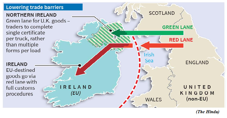
How does the Windsor framework attempt to resolve trade issues?
- The Windsor framework does so by permitting free trade between Great Britain and Northern Ireland through the use of green and red lanes for goods flowing into Northern Ireland.
- Green lane goods will have fewer checks and controls, including no customs checks or rules of origin. Red lane goods under the framework will be subject to full checks and controls to preserve the EU’s single market.
- In a bid to ease the impact on farmers, agri-food goods such as meat and dairy will have reduced checks and controls, and food retailers, including supermarkets, wholesalers, and caterers, will be able to move agri-food via the green lane. The prohibition on certain chilled meats from Great Britain being sold in Northern Ireland will be removed.
- The U.K. and EU leaders are hoping that this would lead to greater availability of British goods in Northern Ireland markets, including both foods and medicines.
Will the framework resolve all outstanding trade issues in the area?
- While the Windsor arrangement is aimed at protecting Northern Ireland’s position within the U.K., and restoring its people’s sovereignty, it is by no means an established working arrangement yet.
- For one, British Prime Minister might be anticipating political blowback from hard-line Tory Brexiteers, who might be incensed at the continuing applicability of some EU customs rules in Northern Ireland.
- Objections to the new arrangement might also be centred on the ‘Stormont brake’, an emergency measure that permits Northern Ireland’s devolved government to quickly halt new EU laws from being imposed on the province, a measure that London retains the right to veto.
- Second, the U.K. and the EU will have to pass new legislation to implement some parts of the framework, especially the proposed regulations in areas such as regulation of trade in medicines, and checks on animals and plants.
- Ultimately, which EU rules will be accepted in Northern Ireland and which will not, depend on the balance of power between the Unionists and Republicans in the province. However, the Windsor framework certainly scores points as a pragmatic compromise with the EU.
Constitution of Greater Panna Landscape Council
(GS Paper 2, Governance)
Why in news?
- As part of the Ken-Betwa Link Project (KBLP), which is game-changer for the socio-economic prosperity of the drought prone Bundelkhand region, a comprehensive Integrated Landscape Management Plan (ILMP) has been prepared for the conservation of wildlife and biodiversity in Panna Tiger Reserve (PTR) & surrounding areas.
- To ensure systematic and time bound implementation of the Greater Panna Landscape Management plan, the Greater Panna Landscape Council (GPLC) has been constituted under the chairmanship of Chief Secretary, Govt. of Madhya Pradesh with members from all the stakeholders.
Objective:
- The goal of the GPL and the council is to ensure a “win-win” situation for conservation through integration with the development process based on a balanced approach and considering the diverse stakes.
- The broad objectives are
- to enable betterment of habitat, protection, and management for flagship species viz. tiger, vulture, and gharial in the landscape;
- to consolidate the landscape for overall biodiversity conservation through spatial prioritization and well-being of the forest dependent communities; and
- to provide species-specific and site-specific monitoring strategies under the integrated landscape management in context with feedback loop and adaptive management options.
Conservation efforts under Ken-Betwa Link Project (KBLP):
About KBLP:
- This project involves transfer of water from the Ken to the Betwa River through the construction of Daudhan Dam and a canal linking the two rivers, the Lower Orr Project, Kotha Barrage -and Bina Complex Multipurpose Project.
- The project will provide an annual irrigation of 10.62 lakh ha, drinking water supply to a population of about 62 lakhs and also generate 103 MW of hydropower and 27 MW solar power. The Project is proposed to be implemented in 8 years with state of the art technology.
- The Project will be of immense benefit to the water starved Bundelkhand region, spread across the states of MP and UP. This project will provide enormous benefits to the districts of Panna, Tikamgarh, Chhatarpur, Sagar, Damoh, Datia, Vidisha, Shivpuri and Raisen of Madhya Pradesh and Banda, Mahoba, Jhansi & Lalitpur of Uttar Pradesh.
- The project is expected to boost socio-economic prosperity in the backward Bundelkhand region on account of increased agricultural activities and employment generation. It would also help in arresting distress migration from this region.
- This project also comprehensively provides for environment management and safeguards. For this purpose a comprehensive landscape management plan is under finalization by Wildlife Institute of India.
Union Minister launched Star-rated appliances program
(GS Paper 3, Environment)
Why in news?
- Recently, the Union Minister of Power and New & Renewable Energy, while commending the contribution of the Bureau of Energy Efficiency in building an energy-efficient economy, launched the Star-rated appliances program and also hailed the completion of a decade of PAT Scheme.
- He was speaking at a function to celebrate the 21st Foundation Day of Bureau of Energy Efficiency in New Delhi.

Voluntary Star Labelling Programme:
- He launched the Voluntary Star Labelling Programme for multi-door refrigerators, table and wall-mounted fans, pedestal fans, and induction hobs.
- This program is expected to save approximately 11.2 billion units of electricity by 2030 and will enable the reduction of CO2 emission close to 9 million tonne by 2030 and shall support India to transition towards low carbon sustainable growth and achieve its ambition of net zero by 2070.
- To enhance the impact of PAT, a program namely DEEP (Demonstration of Energy Efficient Project) is being implemented. While celebrating the decade of PAT, MoUs were signed by Designated Consumers (DCs).
- Total 13 energy intensive sectors including more than 1000 Designated Consumers were covered during this period. These sectors have been able to realise a total of 24 MToE energy savings during this period which is equivalent to emission reduction of 106 MTCO2.
Implementation:
- Spearheading the country’s initiatives on various levels, the Star-labelling program formulated by the BEE under the Energy Conservation Act, 2001, now covers 34 appliances, including the four newly added energy-efficient appliances.
- The voluntary program of these newly added appliances will be effective from March 1, 2023.
- The BEE is implementing several other innovative energy efficiency schemes and national programs that have been successfully designed and implemented like the PAT Scheme, Standards and Labelling for Energy Efficient Appliances, Energy Conservation Building Codes (ECBC), Demand Side Management etc.
iDEEKSHA Portal:
- He also launched the iDEEKSHA Portal. Industrial Decarbonization and EE Knowledge-Sharing Platform, iDEEKSHA is a platform developed under the Accelerating Smart Power and Renewable Energy (ASPIRE) Technical 1 Assistance Programme.
- ASPIRE is a bilateral program implemented by Foreign Commonwealth and Development Office, Government of UK in association with Ministry of Power and Ministry of New and Renewable Energy.
- iDEEKSHA is designed to serve as one-stop shop for all energy efficiency and decarbonisation needs of Indian energy-intensive industries.
- It aims to facilitate the exchange of information, knowledge and experience and best practices related to the wide gamut of stakeholders such as industries, industrial associations, technology and service providers, and research institutions etc.
About BEE:
- BEE is a statutory body under the Ministry of Power, Government of India.
- It assists in developing policies and strategies with the primary objective of reducing the energy intensity of the Indian economy.
- BEE coordinates with designated consumers, designated agencies, and other organizations to identify and utilize the existing resources and infrastructure, in performing the functions assigned to it under the Energy Conservation Act.